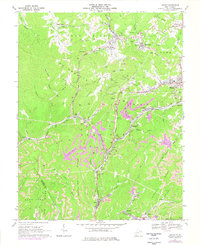
1967 Map of Lester
USGS Topo · Published 1977About this map
Guyandotte Mountain and the surrounding ridges of Raleigh County define this landscape of intensive coal extraction during the late 1960s and mid-1970s. The map illustrates a complex network of strip mines and mine dumps that dominate the terrain between Slab Fork and Stotesbury. The industrial character of the region is further evidenced by the extensive reach of the Norfolk and Western and Chesapeake and Ohio railroads, which thread through narrow valleys to serve coal camps and towns like Tams, Helen, and Eastgulf.
Find a feature on this map
62 named features on this map. Tap any name to fly to it.
Don’t see what you’re looking for? This feature index may not catch every label — zoom into the map to look around manually.
Map Details
Editions of this 1967 Lester Map
2 editions found
Other maps of this area

1891 · Raleigh
USGS Topo · 1:125,000

1897 · Raleigh
USGS Topo · 1:125,000

1902 · Raleigh
USGS Topo · 1:125,000

1911 · Marshes
USGS Topo · 1:48,000

1911 · Flattop
USGS Topo · 1:48,000

1911 · Beckley
USGS Topo · 1:48,000

1912 · Mullens
USGS Topo · 1:62,500

1913 · Beckley
USGS Topo · 1:62,500

1914 · Eccles
USGS Topo · 1:62,500

1914 · Flattop
USGS Topo · 1:62,500