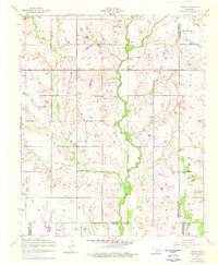
1956 Map of Letitia
USGS Topo · Published 1976About this map
Beaver Creek and its tributary Dry Beaver Creek dominate the landscape of south-central Oklahoma in this mid-century survey, which reveals a transition from agrarian roots to modern infrastructure. Small rural communities such as Pumpkin Center, Letitia, and Bethel are scattered throughout the quadrangle, connected by a network of unimproved roads and a prominent Pipeline. The area's commitment to local education and civic life is evident through numerous named schools like the Beaver Bend School and Fairview School, alongside the Pleasant Valley Community House. Historical industrial activity is also visible in the form of several Oil wells and Slush tanks, indicating the early footprint of the energy sector in Comanche and Cotton counties. These details provide a clear view of Oklahoma's rural character before the intensification of 20th-century development.
Find a feature on this map
26 named features on this map. Tap any name to fly to it.
Don’t see what you’re looking for? This feature index may not catch every label — zoom into the map to look around manually.
Map Details
Editions of this 1956 Letitia Map
2 editions found
Other maps of this area

1946 · Lawton
USGS Topo · 1:62,500

1949 · Arbuckle Hill
USGS Topo · 1:24,000

1949 · Nellie
USGS Topo · 1:62,500

1955 · Lawton
USGS Topo · 1:250,000

1956 · Sterling
USGS Topo · 1:24,000

1956 · Ninemile Creek
USGS Topo · 1:24,000

1956 · Arbuckle Hill
USGS Topo · 1:24,000
1956 · Denton
USGS Topo · 1:24,000

1956 · Letitia
USGS Topo · 1:24,000

1956 · Nellie
USGS Topo · 1:24,000