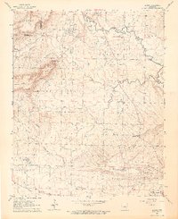
1962 Map of Letona
USGS Topo · Published 1964About this map
Big Creek meanders across the northern reaches of this White County landscape, defining the rural character of the area in the early 1960s. The settlement of Letona sits at a crossroads near the creek, while the presence of the Morris Institute and several country churches like Foster Chapel and Smyrna Ch speak to the established community structure of the time. The terrain is marked by significant elevations such as Mount Pisgah and the prominent Backbone Ridge to the south.
Find a feature on this map
40 named features on this map. Tap any name to fly to it.
Don’t see what you’re looking for? This feature index may not catch every label — zoom into the map to look around manually.
Map Details
Editions of this 1962 Letona Map
3 editions found
Other maps of this area

1932 · Kensett
USGS Topo · 1:62,500

1935 · Kensett
USGS Topo · 1:62,500

1935 · Bald Knob
USGS Topo · 1:62,500

1953 · Memphis
USGS Topo · 1:250,000

1956 · Memphis
USGS Topo · 1:250,000

1962 · Pangburn
USGS Topo · 1:24,000

1962 · Letona
USGS Topo · 1:24,000

1963 · Garner
USGS Topo · 1:24,000

1963 · Floyd
USGS Topo · 1:24,000

1963 · West Pangburn
USGS Topo · 1:24,000