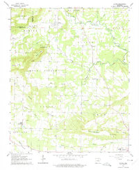
1962 Map of Letona
USGS Topo · Published 1975About this map
Letona serves as a primary settlement point in this mid-century portrait of northern White County, where the landscape transitions from the flats of Big Creek to the prominent rise of Mount Pisgah. The map reveals a community defined by its rural institutions and the lingering infrastructure of early transport, notably the Old Railroad Grade that cuts through the central terrain. Local genealogy is well-represented through scattered landmarks such as Morris Institute, the New Hope Cem, and Smyrna Ch. The geography is intricately carved by a network of waterways including Panther Branch and Little Creek, which separate small communities like Crosby and Albion. From the heights of Backbone Ridge in the south to the northern border with Cleburne County, this survey documents the interplay between agricultural clearings and the timbered ridges characteristic of the region before modern development altered the local rural character.
Find a feature on this map
39 named features on this map. Tap any name to fly to it.
Don’t see what you’re looking for? This feature index may not catch every label — zoom into the map to look around manually.
Map Details
Editions of this 1962 Letona Map
3 editions found
Other maps of this area

1932 · Kensett
USGS Topo · 1:62,500

1935 · Kensett
USGS Topo · 1:62,500

1935 · Bald Knob
USGS Topo · 1:62,500

1953 · Memphis
USGS Topo · 1:250,000

1956 · Memphis
USGS Topo · 1:250,000

1962 · Pangburn
USGS Topo · 1:24,000

1962 · Letona
USGS Topo · 1:24,000

1963 · Garner
USGS Topo · 1:24,000

1963 · Floyd
USGS Topo · 1:24,000

1963 · West Pangburn
USGS Topo · 1:24,000