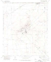
1973 Map of Leuhman Ridge
USGS Topo · Published 1976About this map
Edwards Air Force Base occupies the majority of this high-desert landscape in the early 1970s, dominated by the sprawling operations of the Air Force Flight Test Center. The terrain is punctuated by the prominent Leuhman Ridge, which serves as a literal and figurative high point for military research, housing the Rocket Propulsion Laboratory and various specialized facilities like an Observation Tower and a Heliport. The infrastructure here reflects a landscape dedicated to aerospace development, where Mars Blvd and Mercury Blvd connect remote installations to the outside world.
Find a feature on this map
37 named features on this map. Tap any name to fly to it.
Don’t see what you’re looking for? This feature index may not catch every label — zoom into the map to look around manually.
Map Details
Editions of this 1973 Leuhman Ridge Map
3 editions found
Other maps of this area

1915 · Searles Lake
USGS Topo · 1:250,000

1937 · Kramer
USGS Topo · 1:48,000

1937 · Rogers Lake
USGS Topo · 1:48,000

1942 · Kramer
USGS Topo · 1:62,500

1942 · Rogers Lake
USGS Topo · 1:62,500

1943 · Castle Butte
USGS Topo · 1:62,500

1947 · Castle Butte
USGS Topo · 1:50,000

1947 · Kramer
USGS Topo · 1:24,000

1947 · Johannesburg SE
USGS Topo · 1:25,000

1947 · Rich
USGS Topo · 1:24,000