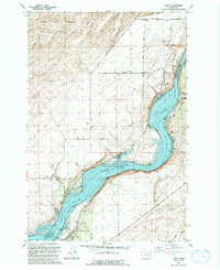
1991 Map of Levey
USGS Topo · Published 1992About this map
Lake Sacajawea dominates the landscape of this 1991 revision, where the Snake River forms the natural boundary between Franklin and Walla Walla counties. The map captures a transition from the desert-like environment of the Juniper Dunes Wilderness in the northwest to the regulated waters of the reservoir. Small settlements like Levey and Ash are clustered near the riverbank, serving as focal points for local infrastructure, including a series of pumping stations and storage facilities. The presence of several parks such as Levey Park, Fishhook Park, and Charbonneau Park indicates the area's development for recreation following the damming of the river. Inland, the map details a network of rural roads like Pasco Kahlotus Road and Klunot Road, connecting isolated Gravel Pits and borrow pits that supported the region's mid-century expansion.
Find a feature on this map
29 named features on this map. Tap any name to fly to it.
Don’t see what you’re looking for? This feature index may not catch every label — zoom into the map to look around manually.
Map Details
Editions of this 1991 Levey Map
This is the sole edition of this map. No revisions or reprints were ever made.
Other maps of this area

1915 · Wallulah
USGS Topo · 1:96,000

1918 · Wallula
USGS Topo · 1:125,000

1953 · Walla Walla
USGS Topo · 1:250,000

1958 · Walla Walla
USGS Topo · 1:250,000

1963 · Rye Grass Coulee
USGS Topo · 1:24,000

1964 · Levey SW
USGS Topo · 1:24,000

1964 · Levey SE
USGS Topo · 1:24,000

1964 · Slater
USGS Topo · 1:24,000

1964 · Levey NE
USGS Topo · 1:24,000

1964 · Humorist
USGS Topo · 1:24,000