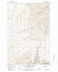
1964 Map of Levey SW
USGS Topo · Published 1983About this map
Sand Dunes dominate the northeastern portion of this Franklin County landscape, illustrating the arid and shifting terrain typical of the region before extensive irrigation. Infrastructure in the mid-1960s was centered on the Spokane Portland and Seattle railroad corridor and the Pasco Kahlotus Road, which served as the primary transit arteries through the open country. Local utility and agricultural needs are evidenced by scattered features such as a Well Water Tank, a Dry Well, and a Gravel Pit. The map captures a moment when the area remained largely defined by its natural topography and resource extraction, with a network of Jeep Trails and minor roads like Rogers Road and Martindale Road providing access to the interior. A prominent Pipeline also traverses the quadrangle, highlighting the industrial connectivity of the rural Pacific Northwest.
Find a feature on this map
14 named features on this map. Tap any name to fly to it.
Don’t see what you’re looking for? This feature index may not catch every label — zoom into the map to look around manually.
Map Details
Editions of this 1964 Levey SW Map
3 editions found
Other maps of this area

1915 · Wallulah
USGS Topo · 1:96,000

1917 · Pasco
USGS Topo · 1:125,000

1918 · Wallula
USGS Topo · 1:125,000

1953 · Walla Walla
USGS Topo · 1:250,000

1958 · Walla Walla
USGS Topo · 1:250,000

1963 · Rye Grass Coulee
USGS Topo · 1:24,000

1964 · Levey SW
USGS Topo · 1:24,000

1964 · Levey SE
USGS Topo · 1:24,000

1964 · Slater
USGS Topo · 1:24,000

1964 · Levey NE
USGS Topo · 1:24,000