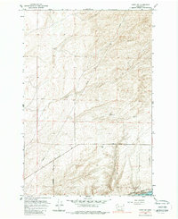
1964 Map of Levey SW
USGS Topo · Published 1988About this map
Snake River frontage and the shifting topography of the Sand Dunes dominate this 1964 survey of the Washington interior. The landscape is defined by the critical infrastructure of the mid-20th century, including the Burlington Northern railroad corridor and the massive Ice Harbor Dam at the southern edge. The map reveals a transition from the river's industrial and hydroelectric focus to the arid uplands of Franklin Co, crossed by essential transport routes like the Pasco Kahlotus Road and Martindale Road. Scattered across the terrain, utilitarian features such as a Dry Well, Gravel Pit, and several Water Tanks indicate the logistical challenges of managing this environment. This survey captures a specific moment when the regional economy was tightly bound to the development of the river system and the maintenance of long-distance transport networks through the dunes.
Find a feature on this map
17 named features on this map. Tap any name to fly to it.
Don’t see what you’re looking for? This feature index may not catch every label — zoom into the map to look around manually.
Map Details
Editions of this 1964 Levey SW Map
3 editions found
Other maps of this area

1915 · Wallulah
USGS Topo · 1:96,000

1917 · Pasco
USGS Topo · 1:125,000

1918 · Wallula
USGS Topo · 1:125,000

1953 · Walla Walla
USGS Topo · 1:250,000

1958 · Walla Walla
USGS Topo · 1:250,000

1963 · Rye Grass Coulee
USGS Topo · 1:24,000

1964 · Levey SW
USGS Topo · 1:24,000

1964 · Levey SE
USGS Topo · 1:24,000

1964 · Slater
USGS Topo · 1:24,000

1964 · Levey NE
USGS Topo · 1:24,000