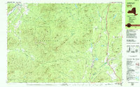
1978 Map of Lewbeach
USGS Topo · Published 1979About this map
The Adirondack Mountains dominate this landscape, which includes several small communities and significant natural landmarks in the late 1970s. The settlement of Jay sits near the Ausable River East Branch, where a Covered Bridge and Roadside Park mark the crossing. To the south and east, the town of Lewis serves as a local hub near Milholland Park and the Thrall Dam Park. The terrain is characterized by named peaks like Saddleback Mtn, Death Mtn, and Hog Back Mtn, interspersed with smaller hamlets such as Stowersville and Crowningshield.
Find a feature on this map
130 named features on this map. Tap any name to fly to it.
Don’t see what you’re looking for? This feature index may not catch every label — zoom into the map to look around manually.
Map Details
Editions of this 1978 Lewbeach Map
This is the sole edition of this map. No revisions or reprints were ever made.
Other maps of this area

1894 · Elizabethtown
USGS Topo · 1:62,500

1894 · Port Henry
USGS Topo · 1:62,500

1895 · Willsboro
USGS Topo · 1:62,500

1895 · Elizabethtown
USGS Topo · 1:62,500

1895 · Mt. Marcy
USGS Topo · 1:62,500

1895 · Ausable
USGS Topo · 1:62,500

1896 · Lake Placid
USGS Topo · 1:62,500

1898 · Port Henry
USGS Topo · 1:62,500

1898 · Lake Placid
USGS Topo · 1:62,500

1901 · Elizabethtown
USGS Topo · 1:62,500