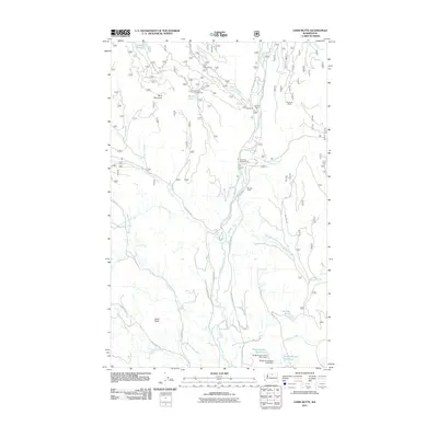
2011 Map of Lewis Butte
USGS Topo · Published 2011About this map
The Chewuch River corridor dominates this 2011 survey, carving a deep path between the prominent peaks of Buck Mountain and Lewis Butte. This landscape in Okanogan County reflects a mix of remote forest management and recreational land use, featuring a network of National Forest roads such as Nat For Dev Rd 100 and Nat For Dev Rd 51. Settled history is anchored by Eightmile Ranch near the river's edge, while the high country is dotted with primitive sites like Flat Campground and Buck Lake Campground. The southern portion of the sheet shows evidence of water management and irrigation through the Wright Ponds- West Pond Dam and Wright Ponds- East Pond Dam, which capture the flow of Pearrygin Creek. Numerous seasonal drainages including Pete Creek and Ramsey Creek define the complex topography of the foothills.
Find a feature on this map
43 named features on this map. Tap any name to fly to it.
Don’t see what you’re looking for? This feature index may not catch every label — zoom into the map to look around manually.
Map Details
Editions of this 2011 Lewis Butte Map
This is the sole edition of this map. No revisions or reprints were ever made.
Other maps of this area

1899 · Methow
USGS Topo · 1:125,000

1901 · Methow
USGS Topo · 1:125,000

1955 · Concrete
USGS Topo · 1:250,000

1958 · Concrete
USGS Topo · 1:250,000

1962 · Concrete
USGS Topo · 1:250,000

1962 · Mazama
USGS Topo · 1:62,500

1963 · Doe Mountain
USGS Topo · 1:62,500
1969 · Thompson Ridge
USGS Topo · 1:24,000
1969 · Buttermilk Butte
USGS Topo · 1:62,500
1969 · Twisp
USGS Topo · 1:62,500