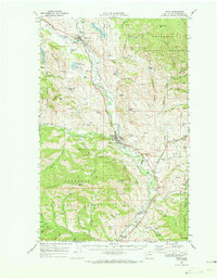
1969 Map of Twisp
USGS Topo · Published 1973About this map
The Methow River valley serves as the central artery for this late 1960s landscape, where the confluence of the Twisp River and the Chewack River shaped the primary settlements of Twisp and Winthrop. This survey captures a region defined by its transition from resource extraction to early recreation, evidenced by the proximity of the Alder Mine and Minnie Mine to the developing Pearrygin Lake State Park. Along the valley floor, local infrastructure such as the Winthrop High Sch, Allen Sch, and a Fish Hatchery near the riverbanks reflect a established community life. To the west and east, the terrain rises into the Okanogan National Forest, marked by peaks like McClure Mtn and Mt Leecher. Smaller family-named landmarks and water bodies, including Jim Johnson Lake and Patterson Lake, dot the coulees and canyons, providing a detailed record of the rural habitation patterns before significant modern expansion.
Find a feature on this map
85 named features on this map. Tap any name to fly to it.
Don’t see what you’re looking for? This feature index may not catch every label — zoom into the map to look around manually.
Map Details
Editions of this 1969 Twisp Map
This is the sole edition of this map. No revisions or reprints were ever made.
Other maps of this area

1899 · Methow
USGS Topo · 1:125,000

1901 · Methow
USGS Topo · 1:125,000

1905 · Okanogan
USGS Topo · 1:125,000

1906 · Chopaka
USGS Topo · 1:125,000

1954 · Okanogan
USGS Topo · 1:250,000

1955 · Concrete
USGS Topo · 1:250,000

1956 · Loup Loup
USGS Topo · 1:62,500

1956 · Tiffany Mountain
USGS Topo · 1:62,500

1957 · Brewster
USGS Topo · 1:62,500

1958 · Concrete
USGS Topo · 1:250,000