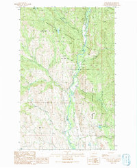
1991 Map of Lewis Butte
USGS Topo · Published 1991About this map
The Chewuch River valley serves as the central corridor for this mountain landscape, which was documented during a 1991 provisional survey based on 1985 aerial photography. The terrain is defined by the steep transition from the Okanogan National Forest in the north to the managed grounds of the Methow State Wildlife Area. Human activity is centered around forest management and recreation, anchored by the Eightmile Ranch FS Station and several remote campsites like Flat Campground.
Find a feature on this map
27 named features on this map. Tap any name to fly to it.
Don’t see what you’re looking for? This feature index may not catch every label — zoom into the map to look around manually.
Map Details
Editions of this 1991 Lewis Butte Map
This is the sole edition of this map. No revisions or reprints were ever made.
Other maps of this area

1899 · Methow
USGS Topo · 1:125,000

1901 · Methow
USGS Topo · 1:125,000

1955 · Concrete
USGS Topo · 1:250,000

1958 · Concrete
USGS Topo · 1:250,000

1962 · Concrete
USGS Topo · 1:250,000

1962 · Mazama
USGS Topo · 1:62,500

1963 · Doe Mountain
USGS Topo · 1:62,500
1969 · Thompson Ridge
USGS Topo · 1:24,000
1969 · Buttermilk Butte
USGS Topo · 1:62,500
1969 · Twisp
USGS Topo · 1:62,500