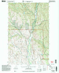
2002 Map of Lewis Butte
USGS Topo · Published 2006About this map
The Chewuch River valley serves as the central corridor for this 2002 revision of the Okanogan highlands, where the Eightmile Ranch Adm Site anchors the northern drainage near the junction of Eightmile Creek. The landscape is defined by the steep elevation changes between Buck Mountain and the prominent Lewis Butte, with the terrain managed under the dual jurisdictions of the Okanogan National Forest and the Methow State Wildlife Area. Water resources are scattered across the high country, including Buck Lake and the smaller Sullivan Pond to the southeast. Industrial activity is noted by a Quarry near the river and additional Quarries in the southern sections, while a network of drainages such as Third Creek, Second Creek, and First Creek carve through the western slopes. This survey reflects a period of forest management and wildlife preservation at the start of the 21st century.
Find a feature on this map
29 named features on this map. Tap any name to fly to it.
Don’t see what you’re looking for? This feature index may not catch every label — zoom into the map to look around manually.
Map Details
Editions of this 2002 Lewis Butte Map
This is the sole edition of this map. No revisions or reprints were ever made.
Other maps of this area

1899 · Methow
USGS Topo · 1:125,000

1901 · Methow
USGS Topo · 1:125,000

1955 · Concrete
USGS Topo · 1:250,000

1958 · Concrete
USGS Topo · 1:250,000

1962 · Concrete
USGS Topo · 1:250,000

1962 · Mazama
USGS Topo · 1:62,500

1963 · Doe Mountain
USGS Topo · 1:62,500
1969 · Thompson Ridge
USGS Topo · 1:24,000
1969 · Buttermilk Butte
USGS Topo · 1:62,500
1969 · Twisp
USGS Topo · 1:62,500