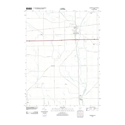
2010 Map of Lewisburg
USGS Topo · Published 2010About this map
Lewisburg and its historic neighbor Euphemia sit at the center of this northern Preble County landscape, where the confluence of Twin Creek and Lick Run defines the local topography. This 2010 survey shows the area's transition from the dense street grids of its historic settlements to the expansive agricultural tracts surrounding Brennersville and New Lexington. Local heritage is anchored by significant sites like Roselawn Cemetery and Myers Cemetery, while transportation history is visible through landmarks such as the Geeting Bridge over Price Creek and the Warnke Bridge on Swamp Creek. The map documents a classic Ohio rural-urban interface, tracing the paths of Bantas Fork and Jims Run as they carve through the farmland toward the larger stream networks of the Great Miami River basin.
Find a feature on this map
65 named features on this map. Tap any name to fly to it.
Don’t see what you’re looking for? This feature index may not catch every label — zoom into the map to look around manually.
Map Details
Editions of this 2010 Lewisburg Map
This is the sole edition of this map. No revisions or reprints were ever made.
Other maps of this area

1905 · Brookville
USGS Topo · 1:62,500

1908 · Miamisburg
USGS Topo · 1:62,500

1911 · Oxford
USGS Topo · 1:62,500

1953 · Cincinnati
USGS Topo · 1:250,000

1957 · Cincinnati
USGS Topo · 1:250,000

1960 · New Madison
USGS Topo · 1:24,000
1960 · Eaton North
USGS Topo · 1:24,000

1960 · Farmersville
USGS Topo · 1:24,000
1960 · Eaton South
USGS Topo · 1:24,000

1961 · Laura
USGS Topo · 1:24,000