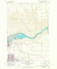
1958 Map of Lewiston Orchards North
USGS Topo · Published 1973About this map
The Clearwater River cuts a sharp path through this landscape, flanked by the steep rising slopes of Lewiston Hill to the north and the developing residential plateaus of Lewiston Orchards to the south. This era shows the community expanding into Valley View Heights, where urban growth indicated in purple begins to fill the space between the older industrial riverfront and the southern residential districts. Infrastructure projects such as the Clearwater River Memorial Bridge and the Substation Powerplant near the river highlight the area's role as a regional energy and transportation hub. Beyond the developed centers of Lewiston and North Lewiston, the terrain transitions into the agricultural expanses of the Camas Prairie, while the Nez Perce Indian Reservation Boundary marks a significant administrative line through the eastern hills near Cole Canyon.
Find a feature on this map
37 named features on this map. Tap any name to fly to it.
Don’t see what you’re looking for? This feature index may not catch every label — zoom into the map to look around manually.
Map Details
Editions of this 1958 Lewiston Orchards North Map
2 editions found
Other maps of this area

1910 · Pullman
USGS Topo · 1:125,000

1945 · Clarkston
USGS Topo · 1:62,500

1948 · Clarkston
USGS Topo · 1:62,500

1955 · Pullman
USGS Topo · 1:250,000

1958 · Pullman
USGS Topo · 1:250,000

1958 · Lapwai
USGS Topo · 1:24,000

1958 · Sweetwater
USGS Topo · 1:24,000

1958 · Lewiston Orchards North
USGS Topo · 1:24,000

1958 · Lewiston Orchards South
USGS Topo · 1:24,000

1958 · Lewiston Orchards
USGS Topo · 1:62,500