
1954 Map of Lewistown
USGS Topo · Published 1973About this map
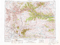
The Judith Mountains dominate the central landscape of this Montana survey, rising sharply above the high plains of Fergus County Petroleum County. This region reflects a complex mid-century balance between agricultural ranching and protected wildlands. The Missouri River cuts a deep path across the north, bordering the Charles M Russell National Wildlife Range and the Fort Belknap Indian Reservation. To the south, the city of Lewistown serves as a regional hub, anchored by the infrastructure of the Chicago Milwaukee St Paul and Pacific and the Great Northern railroads.
Find a feature on this map
119 named features on this map. Tap any name to fly to it.
Don’t see what you’re looking for? This feature index may not catch every label — zoom into the map to look around manually.
Map Details
Editions of this 1954 Lewistown Map
3 editions found

Other maps of this area

1886 · Little Belt Mts.
USGS Topo · 1:250,000

1889 · Big Snowy Mountain
USGS Topo · 1:250,000

1890 · Fort Benton
USGS Topo · 1:250,000

1892 · Fort Benton
USGS Topo · 1:250,000

1893 · Big Snowy Mountain
USGS Topo · 1:250,000

1894 · Little Belt Mts.
USGS Topo · 1:250,000

1897 · Fort Benton
USGS Topo · 1:250,000

1897 · Little Belt Mts.
USGS Topo · 1:250,000

1898 · Little Belt Mts.
USGS Topo · 1:250,000

1902 · Little Belt Mts.
USGS Topo · 1:250,000