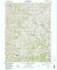
1994 Map of Lewisville
USGS Topo · Published 1998About this map
Lewisville serves as a primary hub for this portion of Monroe County, situated where the Sunfish Creek and Brister Fork drainage systems begin their winding paths through the dissected plateau. The landscape is defined by its deep agricultural and spiritual roots, evidenced by numerous country churches and burial sites like the St Johns Ch and the Free Burial Ground. A significant portion of the eastern terrain is dedicated to the Monroe Lake State Wildlife Area, which surrounds Monroe Lake and its northern tributaries.
Find a feature on this map
54 named features on this map. Tap any name to fly to it.
Don’t see what you’re looking for? This feature index may not catch every label — zoom into the map to look around manually.
Map Details
Editions of this 1994 Lewisville Map
This is the sole edition of this map. No revisions or reprints were ever made.
Other maps of this area

1903 · Macksburg
USGS Topo · 1:62,500

1905 · New Matamoras
USGS Topo · 1:62,500

1905 · Woodsfield
USGS Topo · 1:62,500

1905 · Macksburg
USGS Topo · 1:62,500

1909 · Summerfield
USGS Topo · 1:62,500

1911 · Summerfield
USGS Topo · 1:62,500

1924 · New Matamoras
USGS Topo · 1:62,500

1926 · New Matamoras
USGS Topo · 1:62,500

1949 · Clarksburg
USGS Topo · 1:250,000

1956 · Clarksburg
USGS Topo · 1:250,000