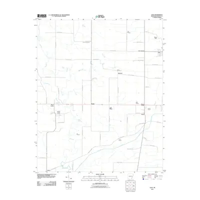
2011 Map of Lexa
USGS Topo · Published 2011About this map
Lexa and its surrounding rural hamlets define this stretch of Phillips County, where the landscape transitions from the higher ground near North Lexa toward the meandering bottomlands of Big Creek. This 2011 survey reveals a dense network of crossroads and family settlements, many centered on small historic cemeteries such as Saint James Cemetery and the uniquely named Hell Cemetery. The agricultural character of the region is evident in the regular grid of Phillips Road routes connecting small communities like Poplar Grove, Blackfoot, and Barton. Waterways like Crooked Creek and Lick Creek cut through the farmland, influencing the placement of original homesteads and local landmarks such as Sunset Memorial Park. The map provides a detailed view of the infrastructure at Lexa Junction, serving as a vital record for genealogists tracing ancestors through these specific Arkansas townships.
Find a feature on this map
54 named features on this map. Tap any name to fly to it.
Don’t see what you’re looking for? This feature index may not catch every label — zoom into the map to look around manually.
Map Details
Editions of this 2011 Lexa Map
This is the sole edition of this map. No revisions or reprints were ever made.
Other maps of this area

1939 · Farrell
USGS Topo · 1:62,500

1939 · Modoc
USGS Topo · 1:62,500

1939 · Latour
USGS Topo · 1:62,500

1940 · Marvell
USGS Topo · 1:62,500

1948 · Helena
USGS Topo · 1:250,000

1948 · Modoc
USGS Topo · 1:62,500

1950 · Helena
USGS Topo · 1:250,000

1955 · Latour
USGS Topo · 1:62,500
1955 · Farrell
USGS Topo · 1:62,500

1955 · Helena
USGS Topo · 1:250,000