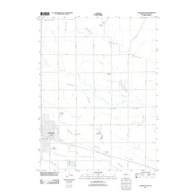
2011 Map of Lexington East
USGS Topo · Published 2011About this map
Lexington serves as the focal point of this Platte River valley landscape, where irrigation infrastructure dictates the patterns of agriculture and settlement. The map reveals an intricate network of water management, from the Dawson County Canal and Sherman Reservoir to smaller works like Beatty Ditch and the Berquist Lateral. These features illustrate the essential role of engineered waterways in Dawson County's development. For local historians, the sheet is a record of community landmarks including the Dawson County Fairgrounds and the Plum Creek Memorial Wall. Several significant burial grounds, such as Mount Hope Cemetery, Greenwood Cemetery, Saint Anns Cemetery, and Evergreen Cemetery, are distributed across the area, providing clear geographic anchors for family history research.
Find a feature on this map
42 named features on this map. Tap any name to fly to it.
Don’t see what you’re looking for? This feature index may not catch every label — zoom into the map to look around manually.
Map Details
Editions of this 2011 Lexington East Map
This is the sole edition of this map. No revisions or reprints were ever made.
Other maps of this area

1896 · Lexington
USGS Topo · 1:125,000

1899 · Lexington
USGS Topo · 1:125,000

1955 · Grand Island
USGS Topo · 1:250,000

1957 · Grand Island
USGS Topo · 1:250,000

1958 · Grand Island
USGS Topo · 1:250,000

1962 · Lexington West
USGS Topo · 1:24,000

1962 · Lexington SE
USGS Topo · 1:24,000
1962 · Buffalo
USGS Topo · 1:24,000
1962 · Sumner
USGS Topo · 1:24,000

1962 · Lexington East
USGS Topo · 1:24,000