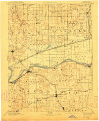
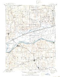
1889 Map of Lexington
USGS Topo · Published 1912About this map
The Missouri River bisects this late 19th-century landscape, acting as both a barrier and a conduit for the region's early growth. The river's dynamics are evident in the shifting channels around Lexington Island and Wolf Island, where the Engineer Corps U. S. Army surveyed the banks a decade before this publication. On the south bank, Lexington stands as a primary hub, connected by the Missouri Pacific Railroad Lexington Branch to inland towns like Higginsville and Page City. North of the river, the landscape is defined by the convergence of several major rail lines, including the Wabash Railroad and the Chicago Santa Fe and St. Louis Railroad at Hardin. Smaller, rural post offices such as Russelville Fox P.O. and scattered settlements like Millville and Georgeville reveal the density of agricultural life across the undulating terrain of Lafayette and Ray counties.
Find a feature on this map
85 named features on this map. Tap any name to fly to it.
Don’t see what you’re looking for? This feature index may not catch every label — zoom into the map to look around manually.
Map Details
Editions of this 1889 Lexington Map
6 editions found
Other maps of this area

1885 · Warrensburg
USGS Topo · 1:125,000

1887 · Harrisonville
USGS Topo · 1:125,000

1887 · Sedalia
USGS Topo · 1:125,000

1887 · Warrensburg
USGS Topo · 1:125,000

1889 · Lexington
USGS Topo · 1:125,000

1890 · Marshall
USGS Topo · 1:125,000

1892 · Marshall
USGS Topo · 1:125,000

1892 · Harrisonville
USGS Topo · 1:125,000

1894 · Harrisonville
USGS Topo · 1:125,000

1894 · Sedalia
USGS Topo · 1:125,000