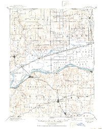
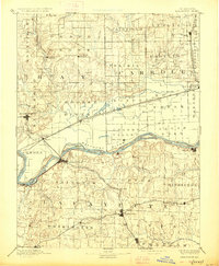
1889 Map of Lexington
USGS Topo · Published 1950About this map
The Missouri River anchors this late-19th-century landscape, serving as the dividing line between the concentrated rail hubs of Lafayette County and the expansive bottomlands to the north. Lexington stands as a prominent riverside center, connected to the north bank via Lexington Junction and the St Joseph and St Louis Railroad. The era's heavy reliance on rail transport is evident in the dense network of lines, including the Santa Fe and California Railroad and the Chicago and St Louis Railroad, which spurred the growth of agricultural shipping points like Hardin, Norborne, and Higginsville. Away from the main river corridor, smaller settlements and post offices like Russelville Fox P.O. and Taitsville mark the rural interior. The topography transitions from the alluvial plains of Cherry Valley to the dissected uplands surrounding Wellington and Odessa, where numerous creeks like Sniabar Creek and Tabo Creek drain toward the Missouri.
Find a feature on this map
85 named features on this map. Tap any name to fly to it.
Don’t see what you’re looking for? This feature index may not catch every label — zoom into the map to look around manually.
Map Details
Editions of this 1889 Lexington Map
6 editions found
Other maps of this area

1885 · Warrensburg
USGS Topo · 1:125,000

1887 · Harrisonville
USGS Topo · 1:125,000

1887 · Sedalia
USGS Topo · 1:125,000

1887 · Warrensburg
USGS Topo · 1:125,000

1889 · Lexington
USGS Topo · 1:125,000

1890 · Marshall
USGS Topo · 1:125,000

1892 · Marshall
USGS Topo · 1:125,000

1892 · Harrisonville
USGS Topo · 1:125,000

1894 · Harrisonville
USGS Topo · 1:125,000

1894 · Sedalia
USGS Topo · 1:125,000