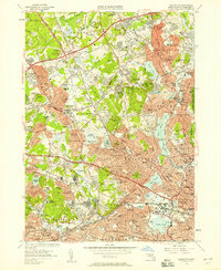
1956 Map of Lexington
USGS Topo · Published 1957About this map
Lexington and its neighboring Middlesex County townships are caught in a moment of post-war suburban transition, where long-standing institutional grounds meet the expanding reach of the Yankee Division Highway. Large parcels of land are dedicated to major medical and state facilities, including the Metropolitan State Hospital, McLean Hospital, and Murphy General Hospital, which stand as prominent landmarks alongside the Fernald State Sch. The map preserves the cultural landscape of the 1950s, marking the Harvard Observatory and local education centers like the Munroe Hill Nursing Sch and Marycliff Academy. In the east, the residential density of Woburn Highlands, Winchester, and Arlington Heights is contrasted by the open waters of the Upper Mystic Lake and the Lower Mystic Lake, while the rail infrastructure of the Boston and Maine continues to define the region's transport corridors. Local history is anchored by Ye Old Burying Ground and numerous neighborhood schools like the Harrington Sch and Lowell Sch.
Find a feature on this map
186 named features on this map. Tap any name to fly to it.
Don’t see what you’re looking for? This feature index may not catch every label — zoom into the map to look around manually.
Map Details
Editions of this 1956 Lexington Map
3 editions found
Other maps of this area

1886 · Lawrence
USGS Topo · 1:62,500

1886 · Lowell
USGS Topo · 1:62,500

1886 · Framingham
USGS Topo · 1:62,500

1888 · Lawrence
USGS Topo · 1:62,500

1889 · Framingham
USGS Topo · 1:62,500

1893 · Lowell
USGS Topo · 1:62,500

1893 · Boston
USGS Topo · 1:62,500

1893 · Lawrence
USGS Topo · 1:62,500

1894 · Framingham
USGS Topo · 1:62,500

1903 · Boston
USGS Topo · 1:62,500