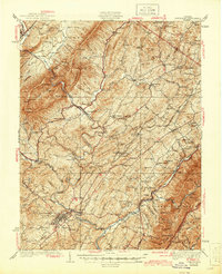
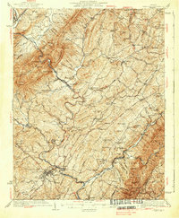
1937 Map of Lexington
USGS Topo · Published 1944About this map
The town of Lexington serves as the focal point for this survey of the central Shenandoah Valley, where the Maury River carves a winding path through the landscape. This era highlights a robust network of small rural schools and local industry, from the Alone Mill Sch to the Big Spring Mill. The confluence of transportation and terrain is evident where the Norfolk and Western and Chesapeake and Ohio railroads parallel the river valleys, connecting established settlements like Goshen and Buena Vista with outlying communities such as Rockbridge Baths and Bustleburg.
Find a feature on this map
195 named features on this map. Tap any name to fly to it.
Don’t see what you’re looking for? This feature index may not catch every label — zoom into the map to look around manually.
Map Details
Editions of this 1937 Lexington Map
3 editions found

Other maps of this area

1894 · Staunton
USGS Topo · 1:125,000

1894 · Natural Bridge
USGS Topo · 1:125,000

1894 · Lexington
USGS Topo · 1:125,000

1894 · Natural Bridge
USGS Topo · 1:62,500

1901 · Monterey
USGS Topo · 1:125,000

1907 · Natural Bridge Special
USGS Topo · 1:62,500

1932 · Lexington
USGS Topo · 1:48,000

1935 · Buena Vista
USGS Topo · 1:48,000

1935 · Amherst
USGS Topo · 1:48,000

1936 · Vesuvius
USGS Topo · 1:48,000