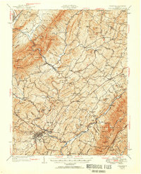
1951 Map of Lexington
USGS Topo · Published 1951About this map
Lexington serves as the focal point of this mid-century survey, situated at the confluence of the Maury River and Woods Creek. The landscape is defined by the steep ridges of the George Washington National Forest, including Jump Mountain and Hogback Mtn, which frame a valley structured by early transportation networks. The Chesapeake and Ohio and Norfolk and Western railroads track the river corridors, supporting established communities like Goshen and Buena Vista.
Find a feature on this map
152 named features on this map. Tap any name to fly to it.
Don’t see what you’re looking for? This feature index may not catch every label — zoom into the map to look around manually.
Map Details
Editions of this 1951 Lexington Map
2 editions found
Other maps of this area

1894 · Staunton
USGS Topo · 1:125,000

1894 · Natural Bridge
USGS Topo · 1:125,000

1894 · Lexington
USGS Topo · 1:125,000

1894 · Natural Bridge
USGS Topo · 1:62,500

1901 · Monterey
USGS Topo · 1:125,000

1907 · Natural Bridge Special
USGS Topo · 1:62,500

1932 · Lexington
USGS Topo · 1:48,000

1935 · Buena Vista
USGS Topo · 1:48,000

1935 · Amherst
USGS Topo · 1:48,000

1936 · Vesuvius
USGS Topo · 1:48,000