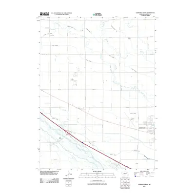
2011 Map of Lexington West
USGS Topo · Published 2011About this map
The Platte River corridor defines this portion of the Nebraska landscape, where a complex network of man-made irrigation channels diverts water to support the region's agricultural economy. Extensive systems including the Cozad Canal, Dawson County Canal, and Thirtymile Canal crisscross the plains, while the Dawson County Drain Number 1 manages the runoff. This reliance on water management is punctuated by industrial and agricultural landmarks like the Darr Feedlot and the river crossing at Darr Bridge. Local history is anchored by the Grace Cemetery and Hewitt Cemetery, alongside the Assemblies of God Conference Grounds. To the east, the edge of Lexington begins to emerge with residential streets such as W 10th St and the regional aviation hub at Jim Kelly Field.
Find a feature on this map
42 named features on this map. Tap any name to fly to it.
Don’t see what you’re looking for? This feature index may not catch every label — zoom into the map to look around manually.
Map Details
Editions of this 2011 Lexington West Map
This is the sole edition of this map. No revisions or reprints were ever made.
Other maps of this area

1896 · Lexington
USGS Topo · 1:125,000

1899 · Lexington
USGS Topo · 1:125,000

1955 · Grand Island
USGS Topo · 1:250,000

1957 · Grand Island
USGS Topo · 1:250,000

1958 · Grand Island
USGS Topo · 1:250,000

1962 · Lexington West
USGS Topo · 1:24,000
1962 · Buffalo
USGS Topo · 1:24,000

1962 · Lexington East
USGS Topo · 1:24,000

1962 · Bertrand NW
USGS Topo · 1:24,000
1962 · Lexington NW
USGS Topo · 1:24,000