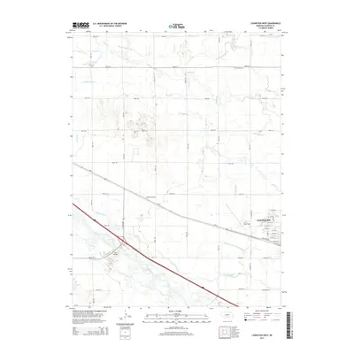
2014 Map of Lexington West
USGS Topo · Published 2014About this map
The braided channels of the Platte River dominate the southern portion of this landscape, reflecting the essential water-management infrastructure of central Nebraska. This 2014 survey documents a complex network of irrigation systems, including the Dawson County Canal, Cozad Canal, and Thirtymile Canal, which define the agricultural productivity of the region. On the western edge of Lexington, residential streets like W Pacific Ave meet industrial and transport hubs such as Jim Kelly Field. Further out into the township, long-established markers of local heritage remain visible at Grace Cem and Hewitt Cem. The presence of the Darr Bridge and various lateral drains, such as the Berquist Lateral, illustrates how the movement of water and people has been engineered across the flat valley floor, where Spring Cr and Buffalo Cr wind toward the larger river system.
Find a feature on this map
48 named features on this map. Tap any name to fly to it.
Don’t see what you’re looking for? This feature index may not catch every label — zoom into the map to look around manually.
Map Details
Editions of this 2014 Lexington West Map
This is the sole edition of this map. No revisions or reprints were ever made.
Other maps of this area

1896 · Lexington
USGS Topo · 1:125,000

1899 · Lexington
USGS Topo · 1:125,000

1955 · Grand Island
USGS Topo · 1:250,000

1957 · Grand Island
USGS Topo · 1:250,000

1958 · Grand Island
USGS Topo · 1:250,000

1962 · Lexington West
USGS Topo · 1:24,000
1962 · Buffalo
USGS Topo · 1:24,000

1962 · Lexington East
USGS Topo · 1:24,000

1962 · Bertrand NW
USGS Topo · 1:24,000
1962 · Lexington NW
USGS Topo · 1:24,000