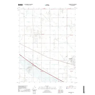
2017 Map of Lexington West
USGS Topo · Published 2017About this map
The western edge of Lexington serves as the focal point for this 2017 survey of the Platte River valley in Dawson County. The landscape is defined by an extensive network of human-engineered irrigation systems, including the Cozad Canal and the Dawson County Canal, which carve through the grid-like agricultural sections. These waterways are essential to the region's farming economy, redirecting water across the flat plains to sustain local crops. Winding through the northern and eastern portions of the map, Spring Cr provides a natural drainage contrast to the linear paths of the canals. The map illustrates the interface between the growing western outskirts of the city and the surrounding rural infrastructure that has supported this Nebraska community for generations.
Find a feature on this map
4 named features on this map. Tap any name to fly to it.
Don’t see what you’re looking for? This feature index may not catch every label — zoom into the map to look around manually.
Map Details
Editions of this 2017 Lexington West Map
This is the sole edition of this map. No revisions or reprints were ever made.
Other maps of this area

1896 · Lexington
USGS Topo · 1:125,000

1899 · Lexington
USGS Topo · 1:125,000

1955 · Grand Island
USGS Topo · 1:250,000

1957 · Grand Island
USGS Topo · 1:250,000

1958 · Grand Island
USGS Topo · 1:250,000

1962 · Lexington West
USGS Topo · 1:24,000
1962 · Buffalo
USGS Topo · 1:24,000

1962 · Lexington East
USGS Topo · 1:24,000

1962 · Bertrand NW
USGS Topo · 1:24,000
1962 · Lexington NW
USGS Topo · 1:24,000