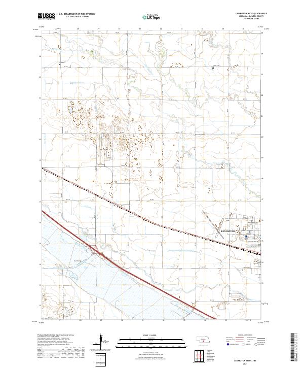
2021 Map of Lexington West
USGS Topo · Published 2021About this map
Lexington serves as the focal point of this Platte River Valley landscape, where an intricate network of irrigation and drainage infrastructure defines the agricultural economy. The Cozad Canal, Thirtymile Canal, and Darr Lateral illustrate the region's reliance on managed water systems to support cultivation across the Nebraska plains. These man-made waterways parallel the Platte River, which cuts across the southern portion of the map, crossed by the Darr Bridge.
Find a feature on this map
43 named features on this map. Tap any name to fly to it.
Don’t see what you’re looking for? This feature index may not catch every label — zoom into the map to look around manually.
Map Details
Editions of this 2021 Lexington West Map
This is the sole edition of this map. No revisions or reprints were ever made.
Other maps of this area

1896 · Lexington
USGS Topo · 1:125,000

1899 · Lexington
USGS Topo · 1:125,000

1955 · Grand Island
USGS Topo · 1:250,000

1957 · Grand Island
USGS Topo · 1:250,000

1958 · Grand Island
USGS Topo · 1:250,000

1962 · Lexington West
USGS Topo · 1:24,000
1962 · Buffalo
USGS Topo · 1:24,000

1962 · Lexington East
USGS Topo · 1:24,000

1962 · Bertrand NW
USGS Topo · 1:24,000
1962 · Lexington NW
USGS Topo · 1:24,000