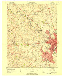
1955 Map of Lexington West
USGS Topo · Published 1956About this map
The prestigious horse-breeding operations and medical institutions of the Bluegrass region define this mid-century survey of the western portion of Lexington. Iconic estates like Calumet Farm and King Ranch Farm occupy significant acreage west of the city, while Bluegrass Field serves the area's growing transportation needs. The map records a dense network of educational and healthcare facilities, including the University of Kentucky, the U S Public Health Service Hospital, and the U S Veterans Hospital.
Find a feature on this map
52 named features on this map. Tap any name to fly to it.
Don’t see what you’re looking for? This feature index may not catch every label — zoom into the map to look around manually.
Map Details
Editions of this 1955 Lexington West Map
This is the sole edition of this map. No revisions or reprints were ever made.
Other maps of this area

1892 · Richmond
USGS Topo · 1:125,000

1897 · Richmond
USGS Topo · 1:125,000

1905 · Harrodsburg
USGS Topo · 1:125,000

1906 · Georgetown
USGS Topo · 1:62,500

1908 · Georgetown
USGS Topo · 1:62,500

1927 · Lexington
USGS Topo · 1:48,000

1929 · Lexington
USGS Topo · 1:62,500

1950 · Lexington East
USGS Topo · 1:24,000

1950 · Lexington West
USGS Topo · 1:24,000

1952 · Keene
USGS Topo · 1:24,000
Featured Places
- Lexington, KY
- Highlands, Lexington
- Elk Chester, Lexington
- Holiday Hills, Lexington
- Garden Springs, Lexington