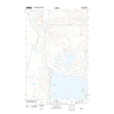
2013 Map of Libby
USGS Topo · Published 2013About this map
The Mississippi River meanders through the western half of this northern Minnesota landscape, where the settlement of Libby sits near the confluence of the Sandy River and the Sandy Lake Reservoir. The eastern and southern portions of the sheet are dominated by a dense network of glacial water bodies, most notably the northern reaches of Big Sandy Lake, which contains Emerald Island. This 2013 survey illustrates a region defined by its complex hydrology, with numerous smaller basins like Oxbow Lake, Aitkin Lake, and Tiesen Lake scattered throughout the wetlands. Local history and genealogy interest is anchored by the Tschibegamig Cem near the northern shore of Big Sandy Lake, and the mapping of access roads like MN-65 and Co HWY-36 that connect these remote water-bound communities. The geography shows a land where travel is dictated by the bypasses of the river and the expansive shorelines of the larger lake systems.
Find a feature on this map
35 named features on this map. Tap any name to fly to it.
Don’t see what you’re looking for? This feature index may not catch every label — zoom into the map to look around manually.
Map Details
Editions of this 2013 Libby Map
This is the sole edition of this map. No revisions or reprints were ever made.
Other maps of this area

1953 · Duluth
USGS Topo · 1:250,000

1958 · Duluth
USGS Topo · 1:250,000

1970 · Tamarack
USGS Topo · 1:24,000

1970 · Rabey
USGS Topo · 1:24,000

1970 · Palisade
USGS Topo · 1:24,000

1970 · Sanders Lake
USGS Topo · 1:24,000
1970 · Vanduse Lake
USGS Topo · 1:24,000

1970 · Balsam
USGS Topo · 1:24,000
1970 · Ball Bluff
USGS Topo · 1:24,000

1970 · Libby
USGS Topo · 1:24,000