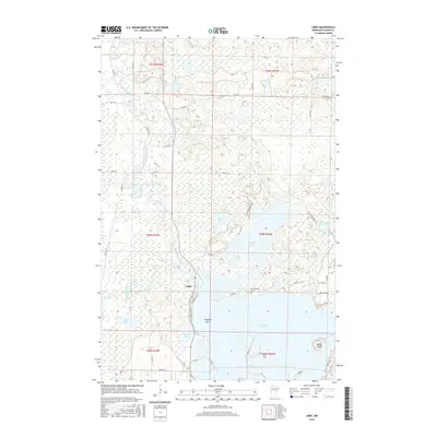
2016 Map of Libby
USGS Topo · Published 2016About this map
The Mississippi River winds through the western reaches of this Aitkin County landscape, defining a terrain shaped by glacial waters and expansive wetlands. Near the center of the sheet, the settlement of Libby serves as a small anchor point north of the confluence where the Sandy River meets the larger river system. The geography is dominated by an intricate network of interconnected water bodies, most notably the northern tip of Big Sandy Lake, which features prominent landforms like Emerald Island and Battle Island. Cultural history is preserved at the Tschibegamig Cem, located along the northern shore of Big Sandy Lake near the mouth of Aitkin Lake. The area's character is further shaped by smaller basins such as Oxbow Lake, Bass Lake, and Tiesen Lake, all connected by a web of local forest roads and lanes like Aitkin Lake Forest Rd.
Find a feature on this map
49 named features on this map. Tap any name to fly to it.
Don’t see what you’re looking for? This feature index may not catch every label — zoom into the map to look around manually.
Map Details
Editions of this 2016 Libby Map
This is the sole edition of this map. No revisions or reprints were ever made.
Other maps of this area

1953 · Duluth
USGS Topo · 1:250,000

1958 · Duluth
USGS Topo · 1:250,000

1970 · Tamarack
USGS Topo · 1:24,000

1970 · Rabey
USGS Topo · 1:24,000

1970 · Palisade
USGS Topo · 1:24,000

1970 · Sanders Lake
USGS Topo · 1:24,000
1970 · Vanduse Lake
USGS Topo · 1:24,000

1970 · Balsam
USGS Topo · 1:24,000
1970 · Ball Bluff
USGS Topo · 1:24,000

1970 · Libby
USGS Topo · 1:24,000