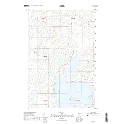
2019 Map of Libby
USGS Topo · Published 2019About this map
The settlement of Libby sits at a geographic crossroads where the Sandy River flows into the northern reaches of Big Sandy Lake. This 2019 survey documents a landscape defined by an intricate network of waterways and glacial lakes in Aitkin County, with the Mississippi River winding along the western edge of the quadrangle. Significant water bodies like Aitkin Lake, Tiesen Lake, and Oxbow Lake dominate the terrain, interspersed with distinctive landforms such as Emerald Island and Battle Island. Cultural markers of the area's heritage are preserved in the mapping of Tschibegamig Cem near the northern shore of Big Sandy Lake. The map illustrates a modern rural infrastructure of county roads and residential lanes, such as Aitkin Lake Forest Rd and Co Hwy 10, providing access to the various peninsulas and lakefronts that characterize this northern Minnesota region.
Find a feature on this map
48 named features on this map. Tap any name to fly to it.
Don’t see what you’re looking for? This feature index may not catch every label — zoom into the map to look around manually.
Map Details
Editions of this 2019 Libby Map
This is the sole edition of this map. No revisions or reprints were ever made.
Other maps of this area

1953 · Duluth
USGS Topo · 1:250,000

1958 · Duluth
USGS Topo · 1:250,000

1970 · Tamarack
USGS Topo · 1:24,000

1970 · Rabey
USGS Topo · 1:24,000

1970 · Palisade
USGS Topo · 1:24,000

1970 · Sanders Lake
USGS Topo · 1:24,000
1970 · Vanduse Lake
USGS Topo · 1:24,000

1970 · Balsam
USGS Topo · 1:24,000
1970 · Ball Bluff
USGS Topo · 1:24,000

1970 · Libby
USGS Topo · 1:24,000