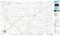
1985 Map of Liberal
USGS Topo · Published 1985About this map
Liberal serves as the primary hub of this High Plains landscape, where the energy industry and agricultural transport networks converge. The map documents an extensive infrastructure of gas fields and refineries south of the Cimarron River, including a massive refinery near the river's winding course. This industrial footprint is balanced by local community landmarks like Graceland Cem and the Municipal Airport serving the town of Meade.
Find a feature on this map
71 named features on this map. Tap any name to fly to it.
Don’t see what you’re looking for? This feature index may not catch every label — zoom into the map to look around manually.
Map Details
Editions of this 1985 Liberal Map
2 editions found
Other maps of this area

1891 · Larned
USGS Topo · 1:125,000

1892 · Meade
USGS Topo · 1:125,000

1892 · Dodge
USGS Topo · 1:125,000

1892 · Spearville
USGS Topo · 1:125,000

1894 · Spearville
USGS Topo · 1:125,000

1896 · Garden
USGS Topo · 1:125,000

1896 · Ashland
USGS Topo · 1:125,000

1900 · Lakin
USGS Topo · 1:125,000

1944 · Moscow
USGS Topo · 1:62,500

1945 · Moscow
USGS Topo · 1:62,500