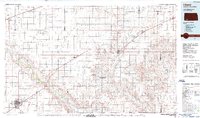
1985 Map of Liberal
USGS Topo · Published 1988About this map
The Artesian Valley and its collection of small lakes and intermittent ponds define this High Plains landscape as it was mapped in the mid-1980s. The regional hub of Liberal anchors the southwest corner, showcasing the expansion of Seward County Comm College and a network of landing fields including the Municipal Airport and Painter Landing Strip.
Find a feature on this map
58 named features on this map. Tap any name to fly to it.
Don’t see what you’re looking for? This feature index may not catch every label — zoom into the map to look around manually.
Map Details
Editions of this 1985 Liberal Map
2 editions found
Other maps of this area

1891 · Larned
USGS Topo · 1:125,000

1892 · Meade
USGS Topo · 1:125,000

1892 · Dodge
USGS Topo · 1:125,000

1892 · Spearville
USGS Topo · 1:125,000

1894 · Spearville
USGS Topo · 1:125,000

1896 · Garden
USGS Topo · 1:125,000

1896 · Ashland
USGS Topo · 1:125,000

1900 · Lakin
USGS Topo · 1:125,000

1944 · Moscow
USGS Topo · 1:62,500

1945 · Moscow
USGS Topo · 1:62,500