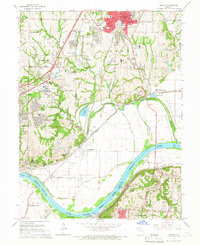
1965 Map of Liberty
USGS Topo · Published 1966About this map
Liberty and its surrounding Clay County landscapes are defined here by a dense network of competing rail lines and the winding course of the Missouri River. The presence of William Jewell College and the Del Bufalo Seminary establishes the area's mid-century role as an educational and institutional hub, while several large quarries along the river bluffs near Cement City point to a thriving industrial base. To the southwest, the industrial expansion of Kansas City reaches toward Claycomo, dominated by a large assembly plant. Local genealogy is well-represented through numerous sites like Fairview Cemetery, New Hope Cemetery, and the Odd Fellows Home. Transportation routes are anchored by the Independence-Liberty Bridge, which links the northern settlements to Independence across the river, while the complex rail junctions at Birmingham and Minaville reflect the heavy freight traffic of the mid-1960s.
Find a feature on this map
57 named features on this map. Tap any name to fly to it.
Don’t see what you’re looking for? This feature index may not catch every label — zoom into the map to look around manually.
Map Details
Editions of this 1965 Liberty Map
3 editions found
Other maps of this area

1890 · Kansas City
USGS Topo · 1:125,000

1894 · Kansas City
USGS Topo · 1:125,000

1894 · Independence
USGS Topo · 1:125,000

1914 · Smithville
USGS Topo · 1:62,500

1933 · Blue Springs
USGS Topo · 1:24,000

1934 · Independence
USGS Topo · 1:24,000

1935 · Kansas City
USGS Topo · 1:24,000

1935 · Missouri City
USGS Topo · 1:24,000

1935 · North Kansas City
USGS Topo · 1:24,000

1935 · Liberty
USGS Topo · 1:24,000