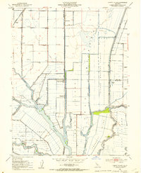
1952 Map of Liberty Island
USGS Topo · Published 1953About this map
Liberty Island and the complex waterway network of the Yolo Bypass dominate this mid-century topographic record of the California Delta. The landscape is defined by its agricultural engineering, featuring an intricate system of levees and cuts like East Cut and West Cut that protect fertile lowlands. Small agricultural hubs and ranching outposts such as Belleair, Mound Ranch, and Liberty Farms are scattered across the tracts, connected by the tracks of the Sacramento Northern railroad.
Find a feature on this map
48 named features on this map. Tap any name to fly to it.
Don’t see what you’re looking for? This feature index may not catch every label — zoom into the map to look around manually.
Map Details
Editions of this 1952 Liberty Island Map
3 editions found
Other maps of this area

1907 · Antioch
USGS Topo · 1:62,500

1908 · Vacaville
USGS Topo · 1:62,500

1908 · Courtland
USGS Topo · 1:62,500

1908 · Antioch
USGS Topo · 1:62,500

1910 · Rio Vista
USGS Topo · 1:31,680

1910 · Isleton
USGS Topo · 1:31,680

1916 · Dixon
USGS Topo · 1:31,680

1916 · Cache Slough
USGS Topo · 1:31,680

1916 · Vorden
USGS Topo · 1:31,680

1916 · Maine Prairie
USGS Topo · 1:31,680