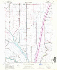
1952 Map of Liberty Island
USGS Topo · Published 1970About this map
The low-lying reclaimed lands of the Sacramento Delta define this landscape, dominated by an intricate network of levees, sloughs, and drainage tracts. The massive Sacramento River Deep Water Ship Channel cuts a straight path through the territory, creating a sharp contrast with the winding natural courses of Cache Slough and Lindsey Slough. This mid-century survey captures a region organized around large-scale agriculture and water management, visible in the designated areas of the Holland Tract and Moore Tract.
Find a feature on this map
37 named features on this map. Tap any name to fly to it.
Don’t see what you’re looking for? This feature index may not catch every label — zoom into the map to look around manually.
Map Details
Editions of this 1952 Liberty Island Map
3 editions found
Other maps of this area

1907 · Antioch
USGS Topo · 1:62,500

1908 · Vacaville
USGS Topo · 1:62,500

1908 · Courtland
USGS Topo · 1:62,500

1908 · Antioch
USGS Topo · 1:62,500

1910 · Rio Vista
USGS Topo · 1:31,680

1910 · Isleton
USGS Topo · 1:31,680

1916 · Dixon
USGS Topo · 1:31,680

1916 · Cache Slough
USGS Topo · 1:31,680

1916 · Vorden
USGS Topo · 1:31,680

1916 · Maine Prairie
USGS Topo · 1:31,680