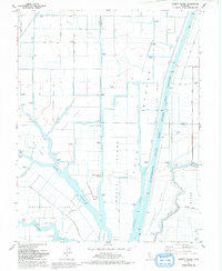
1978 Map of Liberty Island
USGS Topo · Published 1993About this map
Liberty Island and the surrounding marshlands of the California Delta are defined here by a complex network of man-made channels and natural waterways. The Sacramento River Deep Water Ship Channel dominates the eastern landscape, running parallel to the Little Holland Tract Drain and the Sacramento River. This 1970s landscape reflects the intersection of intensive agriculture and resource extraction, anchored by the Maine Prairie Gas Field and scattered infrastructure like storage bins and numerous pumping stations required to manage the low-lying tracts.
Find a feature on this map
44 named features on this map. Tap any name to fly to it.
Don’t see what you’re looking for? This feature index may not catch every label — zoom into the map to look around manually.
Map Details
Editions of this 1978 Liberty Island Map
2 editions found
Other maps of this area

1907 · Antioch
USGS Topo · 1:62,500

1908 · Vacaville
USGS Topo · 1:62,500

1908 · Courtland
USGS Topo · 1:62,500

1908 · Antioch
USGS Topo · 1:62,500

1910 · Rio Vista
USGS Topo · 1:31,680

1910 · Isleton
USGS Topo · 1:31,680

1916 · Dixon
USGS Topo · 1:31,680

1916 · Cache Slough
USGS Topo · 1:31,680

1916 · Vorden
USGS Topo · 1:31,680

1916 · Maine Prairie
USGS Topo · 1:31,680