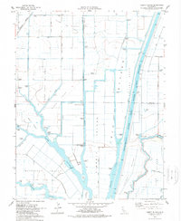
1978 Map of Liberty Island
USGS Topo · Published 1978About this map
The delta landscape of the lower Sacramento River valley is defined here by a complex network of man-made and natural waterways. The Sacramento River Deep Water Ship Channel dominates the eastern half of the map, carving a straight path through the Yolo Bypass and creating a stark contrast to the winding channels of Cache Slough and Miner Slough. This region is divided into distinct reclamation areas like the Maine Prairie Tract and the Hastings Tract, where a reliance on pumping stations reveals the perpetual effort to manage water levels on these low-lying islands. Land use is largely agricultural, centered around the settlement of Liberty Farms. To the north, the Millar Gas Field indicates the subsurface industrial value of the land, while family-named roads like Winship Road and Sikes Road provide a record of local landownership during the late 1970s.
Find a feature on this map
46 named features on this map. Tap any name to fly to it.
Don’t see what you’re looking for? This feature index may not catch every label — zoom into the map to look around manually.
Map Details
Editions of this 1978 Liberty Island Map
2 editions found
Other maps of this area

1907 · Antioch
USGS Topo · 1:62,500

1908 · Vacaville
USGS Topo · 1:62,500

1908 · Courtland
USGS Topo · 1:62,500

1908 · Antioch
USGS Topo · 1:62,500

1910 · Rio Vista
USGS Topo · 1:31,680

1910 · Isleton
USGS Topo · 1:31,680

1916 · Dixon
USGS Topo · 1:31,680

1916 · Cache Slough
USGS Topo · 1:31,680

1916 · Vorden
USGS Topo · 1:31,680

1916 · Maine Prairie
USGS Topo · 1:31,680