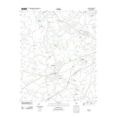
2011 Map of Liberty
USGS Topo · Published 2011About this map
Liberty serves as a central hub in this Upstate South Carolina landscape, where the Liberty Post Office and Grant Memorial Park anchor the local community. The terrain is defined by a series of prominent peaks and watercourses, including Arial Mountain, Mauldin Mountain, and the winding path of Eighteenmile Creek. Numerous smaller settlements and residential developments like Rosewood Heights, Whispering Pines, and Shady Grove are interspersed among the foothills, connected by a dense network of local roads such as Griffin Mill Rd and Old Liberty Rd.
Find a feature on this map
212 named features on this map. Tap any name to fly to it.
Don’t see what you’re looking for? This feature index may not catch every label — zoom into the map to look around manually.
Map Details
Editions of this 2011 Liberty Map
This is the sole edition of this map. No revisions or reprints were ever made.
Other maps of this area

1888 · Pickens
USGS Topo · 1:125,000

1894 · Pickens
USGS Topo · 1:125,000

1951 · Clemson
USGS Topo · 1:24,000

1954 · Greenville
USGS Topo · 1:250,000

1957 · Anderson
USGS Topo · 1:62,500

1957 · Easley
USGS Topo · 1:62,500

1958 · Greenville
USGS Topo · 1:250,000
1961 · Sunset
USGS Topo · 1:24,000
1961 · Six Mile
USGS Topo · 1:24,000
1983 · Piercetown
USGS Topo · 1:24,000