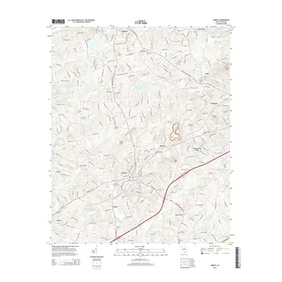
2014 Map of Liberty
USGS Topo · Published 2014About this map
Pickens and Liberty anchor this South Carolina landscape, connected by a network of named highways and historic local roads. The terrain is defined by the drainage basins of Twelvemile Creek, Golden Creek, and Eighteenmile Creek, which flow around prominent elevations such as Arial Mountain and Bogg Mountain. Significant local landmarks include the Pickens County Airport and the Twelvemile River Watershed 12 Reservoir in the northern portion of the quadrangle. For those researching family history in Pickens County, the map identifies numerous local burying grounds including Bethlehem Cemetery, Ruhamah Cemetery, and Grant Memorial Park. The distribution of small settlements like Arial, Beverly, and Five Forks reflects the area's development between the larger hubs of Easley and Norris, where residential patterns often follow the paths of the Gentry Memorial Highway and Moorefield Memorial Highway.
Find a feature on this map
49 named features on this map. Tap any name to fly to it.
Don’t see what you’re looking for? This feature index may not catch every label — zoom into the map to look around manually.
Map Details
Editions of this 2014 Liberty Map
This is the sole edition of this map. No revisions or reprints were ever made.
Other maps of this area

1888 · Pickens
USGS Topo · 1:125,000

1894 · Pickens
USGS Topo · 1:125,000

1951 · Clemson
USGS Topo · 1:24,000

1954 · Greenville
USGS Topo · 1:250,000

1957 · Anderson
USGS Topo · 1:62,500

1957 · Easley
USGS Topo · 1:62,500

1958 · Greenville
USGS Topo · 1:250,000
1961 · Sunset
USGS Topo · 1:24,000
1961 · Six Mile
USGS Topo · 1:24,000
1983 · Piercetown
USGS Topo · 1:24,000