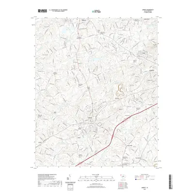
2020 Map of Liberty
USGS Topo · Published 2020About this map
Pickens and Liberty anchor this South Carolina landscape, reflecting a region defined by its numerous rural congregations and family cemeteries. The map reveals a dense network of early 21st-century residential roads such as Allgood Farm Rd and Belle Shoals Rd that thread between the northern Twelvemile Creek and southern Eighteenmile Creek. Many of these routes lead to local gathering places and historical resting sites, including the Bethlehem United Methodist Church Graveyard and the Roanoke Baptist Church Graveyard. Significant topographical features like Arial Mtn and Bogg Mtn rise above the rolling landscape, while industrial and civic operations like the Pickens County Airport and the community of Arial indicate the continued development of Pickens County. The detailed mapping of waterways like Golden Creek and Rices Creek shows how the terrain continues to dictate the layout of these Upstate communities.
Find a feature on this map
68 named features on this map. Tap any name to fly to it.
Don’t see what you’re looking for? This feature index may not catch every label — zoom into the map to look around manually.
Map Details
Editions of this 2020 Liberty Map
This is the sole edition of this map. No revisions or reprints were ever made.
Other maps of this area

1888 · Pickens
USGS Topo · 1:125,000

1894 · Pickens
USGS Topo · 1:125,000

1951 · Clemson
USGS Topo · 1:24,000

1954 · Greenville
USGS Topo · 1:250,000

1957 · Anderson
USGS Topo · 1:62,500

1957 · Easley
USGS Topo · 1:62,500

1958 · Greenville
USGS Topo · 1:250,000
1961 · Sunset
USGS Topo · 1:24,000
1961 · Six Mile
USGS Topo · 1:24,000
1983 · Piercetown
USGS Topo · 1:24,000