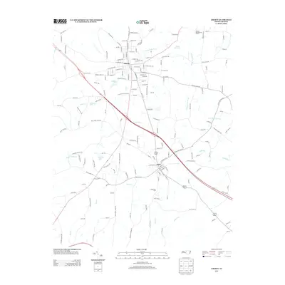
2013 Map of Liberty
USGS Topo · Published 2013About this map
Liberty and the neighboring town of Staley anchor this portion of Randolph County, situated within the drainage basin of the Rocky River. The landscape is a patchwork of small-town street grids and specialized agriculture, evidenced by operations like Fox Turkey Farm and Langley Dairy Farm. The drainage pattern is defined by several water bodies, including Sizemore Lake, Patterson Lake, and Wayne Isley Lake, while the N Rocky River Prong and Brush Cr shape the terrain's topography. Transportation and infrastructure are highlighted by the local presence of the Hinshaw (Greenacres) Airport, serving the rural area north of Staley. The map details a transition from the compact residential streets of Liberty, such as W Swannanoa Ave and N Ashboro St, to the open lands where Mount Pleasant Cr and Reedy Fork meet the rolling countryside.
Find a feature on this map
163 named features on this map. Tap any name to fly to it.
Don’t see what you’re looking for? This feature index may not catch every label — zoom into the map to look around manually.
Map Details
Editions of this 2013 Liberty Map
This is the sole edition of this map. No revisions or reprints were ever made.
Other maps of this area

1953 · Raleigh
USGS Topo · 1:250,000

1954 · Raleigh
USGS Topo · 1:250,000

1968 · Ramseur
USGS Topo · 1:24,000

1968 · Coleridge
USGS Topo · 1:24,000

1969 · Siler City
USGS Topo · 1:24,000

1970 · Kimesville
USGS Topo · 1:24,000
1970 · Climax
USGS Topo · 1:24,000

1974 · Crutchfield Crossroads
USGS Topo · 1:24,000
1974 · Grays Chapel
USGS Topo · 1:24,000
1974 · Liberty
USGS Topo · 1:24,000