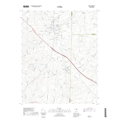
2019 Map of Liberty
USGS Topo · Published 2019About this map
Liberty and Staley anchor this portion of the Piedmont, situated near the corner where Randolph, Alamance, and Chatham counties meet. The landscape is defined by the headwaters of the Rocky River and the N Rocky River Prong, which feed local impoundments such as Sizemore Lake and Wayne Isley Lake. For genealogists and local historians, the area is notably rich in family-named burial grounds, including Amose Grove Cem, Old McMasters Cem, and the Olivers Chapel Cem near Staley. The Hinshaw (Greenacres) Airport occupies the northeastern corner of the map, illustrating the continued aviation presence in this rural corridor. The transport network shows a clear shift toward modern road developments like the bypass running south of Liberty, while traditional routes like Old Liberty Rd and Sandy Creek Church Rd continue to trace the historical movement patterns of the agricultural community.
Find a feature on this map
146 named features on this map. Tap any name to fly to it.
Don’t see what you’re looking for? This feature index may not catch every label — zoom into the map to look around manually.
Map Details
Editions of this 2019 Liberty Map
This is the sole edition of this map. No revisions or reprints were ever made.
Other maps of this area

1953 · Raleigh
USGS Topo · 1:250,000

1954 · Raleigh
USGS Topo · 1:250,000

1968 · Ramseur
USGS Topo · 1:24,000

1968 · Coleridge
USGS Topo · 1:24,000

1969 · Siler City
USGS Topo · 1:24,000

1970 · Kimesville
USGS Topo · 1:24,000
1970 · Climax
USGS Topo · 1:24,000

1974 · Crutchfield Crossroads
USGS Topo · 1:24,000
1974 · Grays Chapel
USGS Topo · 1:24,000
1974 · Liberty
USGS Topo · 1:24,000