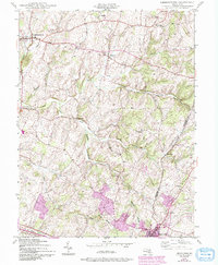
1944 Map of Libertytown
USGS Topo · Published 1994About this map
Libertytown and Mount Airy anchor this detailed study of the Maryland piedmont during the mid-1940s, a landscape defined by its complex network of watercourses and rural hamlets. The boundary between Frederick Co and Carroll Co bisects the terrain, which is deeply carved by the Linganore Creek and its major tributaries, the North Fork and South Fork. Small agricultural and residential clusters like Unionville, Woodville, and Harrisville are connected by a web of country roads, while institutional landmarks such as Ridge Sch No 4 reflect the local social infrastructure. The map reveals a transition from traditional agrarian patterns toward the growth of Mount Airy, with later 20th-century urban expansion noted in purple revisions. Tributaries like Dollyhyde Creek, Weldon Creek, and Bens Branch illustrate the dense drainage pattern that has historically dictated farm placement and road routes in this corner of Maryland.
Find a feature on this map
20 named features on this map. Tap any name to fly to it.
Don’t see what you’re looking for? This feature index may not catch every label — zoom into the map to look around manually.
Map Details
Editions of this 1944 Libertytown Map
4 editions found
Other maps of this area

1893 · Frederick
USGS Topo · 1:125,000

1894 · Frederick
USGS Topo · 1:125,000

1908 · Ijamsville
USGS Topo · 1:62,500

1909 · Mount Airy
USGS Topo · 1:62,500

1909 · Ijamsville
USGS Topo · 1:62,500

1911 · Taneytown
USGS Topo · 1:62,500

1911 · Emmitsburg
USGS Topo · 1:62,500

1942 · Frederick
USGS Topo · 1:62,500

1942 · Gettysburg
USGS Topo · 1:125,000

1943 · Emmitsburg
USGS Topo · 1:62,500