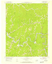
1954 Map of Lick Creek
USGS Topo · Published 1955About this map
The Levisa Fork carves a deep, winding path through the steep terrain of eastern Pike County, serving as the primary corridor for both the Norfolk and Western and Chesapeake and Ohio railroads. This mid-century landscape is defined by its hollow-based settlement patterns, where small communities like Mouthcard and Phyllis follow the river's edge while schools and churches are tucked away in the narrow valleys. Significant local gathering points such as Cedar Bottom Ch and Camp Evangel stand alongside numerous rural schoolhouses, including the Gabriel Branch Sch and Millers Creek Sch. The map reveals the early footprint of the region's extraction economy, noting a Strip Mine and the rail-dependent community at Lick Creek Sta. From the height of Hunt Knob down to the creek confluences, the sheet preserves a specific era of Appalachian geography before major modern development.
Find a feature on this map
112 named features on this map. Tap any name to fly to it.
Don’t see what you’re looking for? This feature index may not catch every label — zoom into the map to look around manually.
Map Details
Editions of this 1954 Lick Creek Map
2 editions found
Other maps of this area

1886 · Grundy
USGS Topo · 1:125,000

1887 · Warfield
USGS Topo · 1:125,000

1890 · Grundy
USGS Topo · 1:125,000

1891 · Warfield
USGS Topo · 1:125,000

1892 · Grundy
USGS Topo · 1:125,000

1909 · Matewan
USGS Topo · 1:48,000

1914 · Hurley
USGS Topo · 1:48,000

1915 · Regina
USGS Topo · 1:48,000

1915 · Hurley
USGS Topo · 1:48,000

1915 · Williamson
USGS Topo · 1:48,000