
1936 Map of Life
USGS Topo · Published 1936About this map
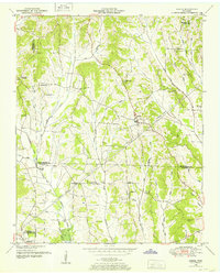
Tennessee Basin Divide dominates the central topography of this 1936 Henderson County survey, partitioning the landscape between various drainage networks. The map documents a rural society deeply rooted in its local institutions, evidenced by the high density of family and community cemeteries such as Mullins Cem, Horn Cem, and Mt Zion Cem. A network of country schools, including Pressler Sch, Laster Sch, and Thomas Sch, are scattered across the terrain, serving small settlements like Life and Stegall. Notable for social historians is the presence of the Poorhouse and its associated County Farm Cem. The region's hydraulic engineering is visible through numerous drainage projects, specifically the Beech River Drainage Ditch and the Middleton Creek Drainage Ditch, which reflect efforts to manage the wetlands within the basin during the mid-1930s.
Find a feature on this map
43 named features on this map. Tap any name to fly to it.
Don’t see what you’re looking for? This feature index may not catch every label — zoom into the map to look around manually.
Map Details
Editions of this 1936 Life Map
This is the sole edition of this map. No revisions or reprints were ever made.
Other maps of this area

1936 · Lexington
USGS Topo · 1:24,000

1936 · Sardis
USGS Topo · 1:24,000

1936 · Reagan
USGS Topo · 1:24,000

1936 · Enville
USGS Topo · 1:24,000

1936 · Chesterfield
USGS Topo · 1:24,000
1949 · Sardis
USGS Topo · 1:24,000

1950 · Reagan
USGS Topo · 1:24,000

1950 · Life
USGS Topo · 1:24,000

1950 · Enville
USGS Topo · 1:24,000

1950 · Lexington
USGS Topo · 1:24,000