
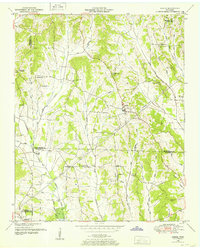
1950 Map of Life
USGS Topo · Published 1952About this map
The Tennessee Valley Divide crests through this 1950s landscape, splitting the drainage between the Beech River system to the north and the Middle Fork Forked Deer River to the south. This rural Tennessee environment is punctuated by institutional landmarks like the Poorhouse and the County Farm Cem, reflecting mid-century social structures in a landscape otherwise defined by small farming communities and family plots. Small schools, including Laster Sch and Life Sch, are scattered along the ridge tops and creek valleys, serving localized settlements such as Life and Palestine.
Find a feature on this map
50 named features on this map. Tap any name to fly to it.
Don’t see what you’re looking for? This feature index may not catch every label — zoom into the map to look around manually.
Map Details
Editions of this 1950 Life Map
This is the sole edition of this map. No revisions or reprints were ever made.
Other maps of this area

1936 · Lexington
USGS Topo · 1:24,000

1936 · Sardis
USGS Topo · 1:24,000

1936 · Reagan
USGS Topo · 1:24,000

1936 · Enville
USGS Topo · 1:24,000

1936 · Life
USGS Topo · 1:24,000

1936 · Chesterfield
USGS Topo · 1:24,000
1949 · Sardis
USGS Topo · 1:24,000

1950 · Reagan
USGS Topo · 1:24,000

1950 · Enville
USGS Topo · 1:24,000

1950 · Lexington
USGS Topo · 1:24,000