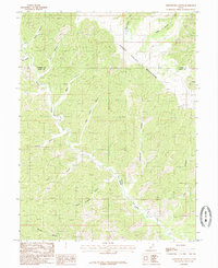
1985 Map of Lighthouse Canyon
USGS Topo · Published 1985About this map
Range Valley Mountain dominates this portion of the East Tavaputs Plateau, marking the high-elevation divide where Carbon and Emery counties meet. The landscape is defined by an intricate network of deep drainages, including Lighthouse Canyon and Cherry Meadow Canyon, which feed into Cherry Meadow Creek. The presence of a Natural Arch near Billy Slope Canyon and various perennial and seasonal water sources like Twin Springs and Barton Creek highlights the specialized topography of this region. This 1985 provisional survey captures the area in a period of relative isolation, showing only unimproved roads and trails navigating the complex terrain around Black Hill and along the county boundary marked by a specific Boundary Marker on the mountain ridge.
Find a feature on this map
20 named features on this map. Tap any name to fly to it.
Don’t see what you’re looking for? This feature index may not catch every label — zoom into the map to look around manually.
Map Details
Editions of this 1985 Lighthouse Canyon Map
This is the sole edition of this map. No revisions or reprints were ever made.
Other maps of this area

1886 · Price River
USGS Topo · 1:250,000

1896 · Price River
USGS Topo · 1:250,000

1915 · Sunnyside
USGS Topo · 1:62,500

1948 · Woodside
USGS Topo · 1:62,500

1949 · Woodside
USGS Topo · 1:62,500

1950 · Woodside
USGS Topo · 1:62,500

1954 · Flat Canyon
USGS Topo · 1:62,500

1954 · Range Creek
USGS Topo · 1:62,500

1956 · Price
USGS Topo · 1:250,000

1960 · Price
USGS Topo · 1:250,000