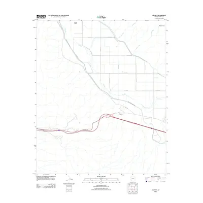
2011 Map of Ligurta
USGS Topo · Published 2011About this map
The Gila River winds through this desert corridor, defining the agriculture and transit patterns of the Dome Valley and the small settlement of Ligurta. Modern infrastructure like the Wellton Mohawk Canal and E Hwy 80 follows the ancient logic of the terrain, tracing a path south of the Muggins Peak highlands. Of significant interest to local historians is the Route of Butterfield Stage, which cuts across the northwest corner of the map, marking the legacy of 19th-century mail and passenger travel through the Arizona territory. The landscape is deeply etched by seasonal drainage systems such as Muggins Wash, Twin Tanks Wash, and West Wash, all flowing toward the river valley. To the west, the steep ascent of Telegraph Pass represents a natural bottleneck that has influenced travelers from the wagon era to the interstate age.
Find a feature on this map
30 named features on this map. Tap any name to fly to it.
Don’t see what you’re looking for? This feature index may not catch every label — zoom into the map to look around manually.
Map Details
Editions of this 2011 Ligurta Map
This is the sole edition of this map. No revisions or reprints were ever made.
Other maps of this area

1926 · Fortuna
USGS Topo · 1:62,500

1926 · Wellton
USGS Topo · 1:62,500

1929 · Fortuna
USGS Topo · 1:62,500

1929 · Laguna
USGS Topo · 1:62,500

1929 · Wellton
USGS Topo · 1:62,500

1942 · Yuma
USGS Topo · 1:250,000

1943 · Laguna
USGS Topo · 1:62,500

1954 · El Centro
USGS Topo · 1:250,000

1955 · El Centro
USGS Topo · 1:250,000
1955 · Dome
USGS Topo · 1:24,000